
 |
| Photo courtesy of Kirsten Severud |
As I set controls I found four large boulders, a medium size meadow, and some forest missing from the map. One of those boulders lay right along a likely route from Int 7 to 8 (Adv 13 to 14). I drew it in on the already printed maps. I had walked within five meters of the other three during my field work. I missed those boulders in spite of the fact that I had mapped 413 features over three days in the field. The map was far from complete, let alone perfect. 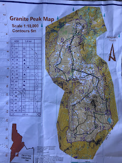 Click on Sergey's map to see the expanded version. Have a look at Sergey's route from 10 to 11. Notice how he proceeded 150 meters on a bearing toward #11 and then veered off to the south. My understanding of what drew him off course was the absence of green slashes in the meadow southwest of the numeral “4”. There was some low dense vegetation with good visibility, but unmapped in that meadow. Sergey saw that vegetation and thought it was represented by the green slashes just east of the numeral “4”. Choosing a route just south of those green slashes would have put him right on course. A major mapping omission produced enough confusion to require Sergey to re-locate to #4 and lose 15-20 minutes. Mea culpa. The map has been corrected, but what other errors lurk out there?
The terrain “reminds me of Switzerland” remark reminds me that most of the quotations about Granite Peak revolved around Karin's contribution to the meet report's title. In addition to world class orienteering terrain it was “super scenic”. Add in a respite from the heat, post-season for mosquitoes, and recent grading of the first four miles of the Snowbank Mountain Road. It was as close to a perfect day as I could imagine.
John Murray

Well, after all of that Sergey was gracious: “World class area!
And amazing map considering that you spent only couple days field checking! The key was to use white wood patches, contours, and large boulders and rock features for navigation. It is very tough terrain physically but so much reminds me of mountain terrain in Switzerland!“ And thanks to Sergey for recommending that we explore Granite Peak. It was his recommendation that put this map into CTOC's growing inventory.
And amazing map considering that you spent only couple days field checking! The key was to use white wood patches, contours, and large boulders and rock features for navigation. It is very tough terrain physically but so much reminds me of mountain terrain in Switzerland!“ And thanks to Sergey for recommending that we explore Granite Peak. It was his recommendation that put this map into CTOC's growing inventory.
 |
| Three Springs at Int 7/ Adv13 --Kirsten |
The terrain “reminds me of Switzerland” remark reminds me that most of the quotations about Granite Peak revolved around Karin's contribution to the meet report's title. In addition to world class orienteering terrain it was “super scenic”. Add in a respite from the heat, post-season for mosquitoes, and recent grading of the first four miles of the Snowbank Mountain Road. It was as close to a perfect day as I could imagine.
 |
| Int 10/Adv16 -- Bill Leahy |
“Super scenic” did have its distractions. If I were to be technically correct tyrant, the Advanced Course would have only one finisher and two DNFs. Bill explained that he spent a lot of time taking photos and chose to exercise his option to drop one control, Adv 14 (Int 8). I didn't know the rules allowed that option. I am grateful for the photos, and Bill is very persuasive. I should note that Kirsten took a whole lot more photos, finished first in the intermediate division, and never skipped a control. Maybe she just wasn't aware of the option.
Melanie baled at Adv 13 after a fall resulting in a thigh wound. It turned out to be a wound she could ignore. Later she went out and picked up the remaining five controls. No way I'm going to DNF someone who saved me the time and effort of picking up controls.
Deciding second and third place puts me in a moral quagmire. Bill dropped # 14 and rested his case on the photography imperative. Melanie quit and restarted after the course was closed. Decide for yourself. 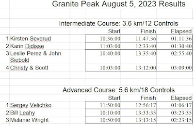

Thank you Melanie and Sergey for the control pickup.
Karin had what I consider to be a very respectable second place finish in tough terrain. The two teams of Leslie and John and Scott and Christy arrived at the finish visibly more satisfied than tired. I know the terrain. I've walked up and down that mountain. I understand the challenges of navigation. Finishing this course as they did is a worthy accomplishment. I want to honor that.
October 14 is a couple of months away. It wasn't too early for Kirsten to be thinking about the Snowbank Meadows Meet. After the meet she drove up the road and took a photo looking down onto the Snowbank Meadows terrain. Keep September 10 open for our next meet. Melanie will direct that meet somewhere in the Idaho City area.
 |
| Snowbank Meadows --Kirsten Severud |
Meet Director
No comments:
Post a Comment