March 27, 2017

Willow Creek Results - March 26, 2017

Jerry Registering

Willow Creek wasn't the first meet that caused me to ponder why so few orienteers showed up to enjoy a new map on terrain so close to Boise. This time there were only seven. After much consternation and much less thought I conjured up an explanation.


Brad
Sergey Finishing
As I recalled the experiences of the last year I began to see a pattern emerge. It was about a year ago that Jeff Black directed a meet on the Queen Mine map newly developed by me. The Mile Marker 14 Fire burned over the map in the middle of July. July brought not only fire, but also a lot of untimely rain. We had scheduled the Pine Creek Meet for July 10 because everyone knows we don't get much rain in July, rain that could render the Pine Creek Road muddy and impassable. Due to the improbable deluge in Boise we postponed the meet for a week. Oh! And then there was more fire. I had made considerable progress mapping the Avimor area when a late July fire negated the work. August didn't work out too well either. My partner, Norma, owns a house in Cascade adjoining terrain full of the kind of features and variations that make an orienteer drool. I had a good start mapping it. The landowner denied us access. Well, so much for 2016. January's frozen ground at Willow Creek seemed like a near ideal venue for our January meet. In case you were hibernating and missed it, we experienced a wee bit more snow than usual in January. By March the snow was gone. Who could have predicted that the March 25 version of the January meet would be delayed due to rain? Maybe a better question is who couldn't?


Perhaps you being somewhat more discerning than your much humbled reporter can see the pattern here I resisted for so long. When John Murray is involved in a meet, something, large or small, recoverable or irredeemable, will go wrong. Apparently a lot of other folks discerned the pattern long before I did and exercised their good judgment to stay away. Hence, the seven orienteers least imbued with wisdom signed up for what promised to be the folly of Willow Creek March 25.

Before discussing the meet itself, I should pass on two pieces of good news. First, I will not be directing the next meet. Instead, the ever reliable Sergey Velichko will titillate us with a new map of the recently completed Esther Simplot Park. And if that's not enticement enough, he hopes to use the new e-punch system. And, second, I won't be directing a meet until October. You are safe to return to orienteering until then.
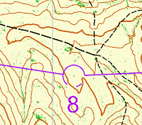
Strangely, a folly it was most emphatically not. Everyone seemed to enjoy the terrain, and nobody complained about the map. That was strange indeed. On the contrary, orienteers found the contours to be accurate, as expected when the elevation model is derived from high resolution LiDAR. Because the only significant vegetation was brush—sagebrush, rabbit brush, and bitterbrush—LiDAR produced a high quality vegetation map to the extent that it identified a single large specimen of brush. The snippet is from Control 8 on the Intermediate Map and Control 12 on the Advanced Map. The circle is about 55 meters in diameter. The green dot in the center is the large sagebrush on which the control bag was hung.


Thanks to a very tired Michael Bading for picking up the most exhausting controls. And, thanks to Jeff Black, who was not entirely recovered from his 100 miler last week for picking up some others.

We look forward to great April weather and Sergey's new map on Saturday, April 8.

John Murray
Meet Director

Doug, Brad, and Bill After Finishing


March 16, 2017

Willow Creek-- Saturday, March 25 – A New LiDAR Map


Come hunt for the willows and the creek on our new Willow Creek Map. Spring weather has brought out the sagebrush buttercups and prairie stars. As for bigger features like creeks and willows this area is like one of those subdivisions utterly lacking in the romance of its fraudulent name. If a creek has to have water and a willow has to be a tree, you will find either only in your hallucinations after an exhausting tour of the advanced course. In my exploration of this large area I haven't found a single boulder, cliff or tree.

Willow Creek calls for endurance, speed, route choice and contour interpretation. The map derived from LiDAR data contains reliable contours with detailed vegetation. The dominant vegetation is sagebrush with rabbit brush and notable bitterbrush. Because these vegetation species have similar properties our LiDAR software identifies detail as fine as individual plants, making vegetation patterns useful navigation guides.

Design for Advanced and Intermediate courses attempts to eliminate gratuitous elevation gain and loss. However, orienteers will encounter several  choices between a longer running route and a shorter climbing/descending route. The Advanced Course has 15 controls over 7.1 k and the Intermediate Course has 11 controls over 4.7 k. There is no truly beginner course. A novice course consisting of 8 controls over 2.0 k will require some familiarity with orienteering maps and the use of a compass. It lacks the large elevation changes on the other two courses.

All three courses (novice, intermediate, and advanced) begin and end in a large parking area east of Eagle Road north of the City of Eagle.
In the desire to minimize waste and save myself some printing expenses, please RSVP to me no later than Thursday March 23 with your name and intended course choice (and if you want an extra map or two for a larger group.)  My email is jnm2870 AT cableone DOT net.  If you decide to show up impromptu, I expect to have a few blanks on hand and you will get to copy your course the old school way. When the maps are gone, they are gone.

Who: Orienteers of all ages, novice to advanced.
When: Saturday March 25. Courses will be open for starts from 9am – 10:00. Courses close at 1:00 pm. You may arrive within this window to try a course, as participants start separately a few minutes apart.

Finish and Parking Location: Willow Creek Parking Area on Eagle Road 3.5 miles north of the Beacon Light/Eagle Road intersection. If you are logged on to Google, you can find the start on this map:
https://drive.google.com/open?id=1WK2EdQnYUYnFdS2oVgII8wVShRQ&usp=sharing

Restrooms are not available. You are responsible for your own water.
Format: Classic. 
Cost:  $10 per person/team, $5 for a single junior, free to CTOC members (more info here)
You may want to bring: a watch, a compass, a snack, a whistle and a cell phone. (Some compasses will be available to borrow.)

A word about LiDAR: Several government agencies have acquired high resolution mapping data for land management. The process involves a low altitude GPS guided laser scan resulting in a digital elevation model with accuracy sometimes in a range below ten centimeters. These data have been made available free to the public in many cases via the Idaho LiDAR Consortium. "In July 2015, Quantum Spatial (QSI) was contracted by Ada County to collect Light Detection and Ranging (LiDAR) data in the fall of 2015 for the Ada County Enhanced Wildfire Risk Map site in Idaho. Data were collected to aid Ada County in assessing the topographic and geophysical properties of the study area to assess and map wildfire hazards in Ada County."
Director: John Murray

March 6, 2017

Inaugural E-Punch Meet at Riverstone Results

First and foremost, special thanks go out to my fantastic maze setters: Innes and Katrina Wright, who spent their Friday evening freezing their fingers to set up the maze.  And to Ben, Sergey, Jeff, and Mike for set up and clean up help.  Thanks to Riverstone for the warm meet center!

Printed splits! John Murray, Alden Koenig, and Sergey Velichko
It was an excellent turnout: seventeen competitors showed up to try out our new e-punch system. Ten competed in the long course and 7 in the short course.  The weather was cold and sunny.  Access to the Riverstone gym with a view of the Maze-O allowed us to stay comfortable and still keep an eye on the action.  A fast course kept runners warm while they were out there. 

Max Cole hitting the corners with speed
To declare a maze champion, I combined the times of Maze 1 (2 in the short course) and 3 (1 in the short course), so that we could group all the competitors together into a single competition.  The results are shown in the table below.  Mike Bading took the maze award, although hitting the maze so fast cost him in the overall course because he mis-punched in the second maze. Sergey Velichko was the top competitor if you were to combine all three mazes, with Todd Dinkelman right behind him.  Among our student and short course competitors, Alden Koenig took the win, followed by Max Cole in second and Katrina Wright in third.


Finding their way without running anyone over: Norma Bailey, Jerry Stewart, and Ole Bergset. 

Jeff Black and Anton Kuzmin in the maze.
The short course was a total of 1.5km with 16 controls, including two trips through the maze (6 controls outside of the maze). Alden Koenig and Max Cole competed from the Riverstone team along with veterans John Murray, Katrina Wright, and Norma Bailey.  We were happy to see Riverstone supporter Jennifer Smackey come out and try her hand. Alden took first place, with John Murray in #2 and Max Cole right behind John for 3rd.  Katrina had a great run leading the ladies and taking 4th overall. Results are below. The blog format makes it tough to show all splits and still have sufficient resolution to read - if you want to see the full splits, let me know. We'll be trying to post to WinSplits.


The long course totaled 3.6 km with 28 controls including three trips through the maze (13 outside the maze with 2 controls that were repeated on 2 of the loops).  Many CTOC veterans came out for the event along with two Riverstone students, Alexis Coussa-Cario and Anton Kuzmin.  Todd Dinkelman was the winner clocking a very fast time of 20:45. Ben Brock took 2nd and Sergey Velichko was just 32 seconds behind Ben in 3rd.  We, unfortunately had 2 dnfs.  Michael Bading, who came in with a time that was only 17 seconds behind Sergey, mis-punched in his second loop of the maze. Anton Kuzmin mis-understood the maps and, although he hit all the controls, visited them out of order. Results are shown in the table below.

Alexis Cousa-Cario took on the long course.

Melanie W and Sergey excited about first prints from the SI system!
Hope to see you in March!  

Race Director,
Melanie Wright