July 19, 2016

Pine Creek Meet Report -- July 17

It was a dark and stormy night morning. That was July 10 when as a consequence of an improbable July downpour in Boise, Horseshoe Bend and McCall I postponed the Pine Creek Meet. Although later reports from the scene proved the postponement unnecessary, at the time it seemed that the risk of problems caused by a very muddy and maybe impassable Forest Service Road 304 was not a good choice.

First, I must apologize to Mike Teller. I arranged to have Sergey pick up some controls off the Intermediate Course before I verified that part of the course to be clear of participants. I have no excuse, only an apology. To make matters worse I recall that I had done the same thing to Ole at the 2014 Bogus Basin Meet and vowed to never make that mistake again. For whatever it's worth (It might not be much if history is any guide.) I am assuring everyone, especially Mike, that it will never happen again.

To Mike's credit, he was gracious. I'm not confident that I would have been so forgiving. He drove up to the meet in spite of his wife's ailing back only to spend fruitless and frustrating time searching for three controls that weren't there. When I caught up to him on the far end of the course, he was right on course without controls to confirm his location. I believe that's the mark of a first rate orienteer.

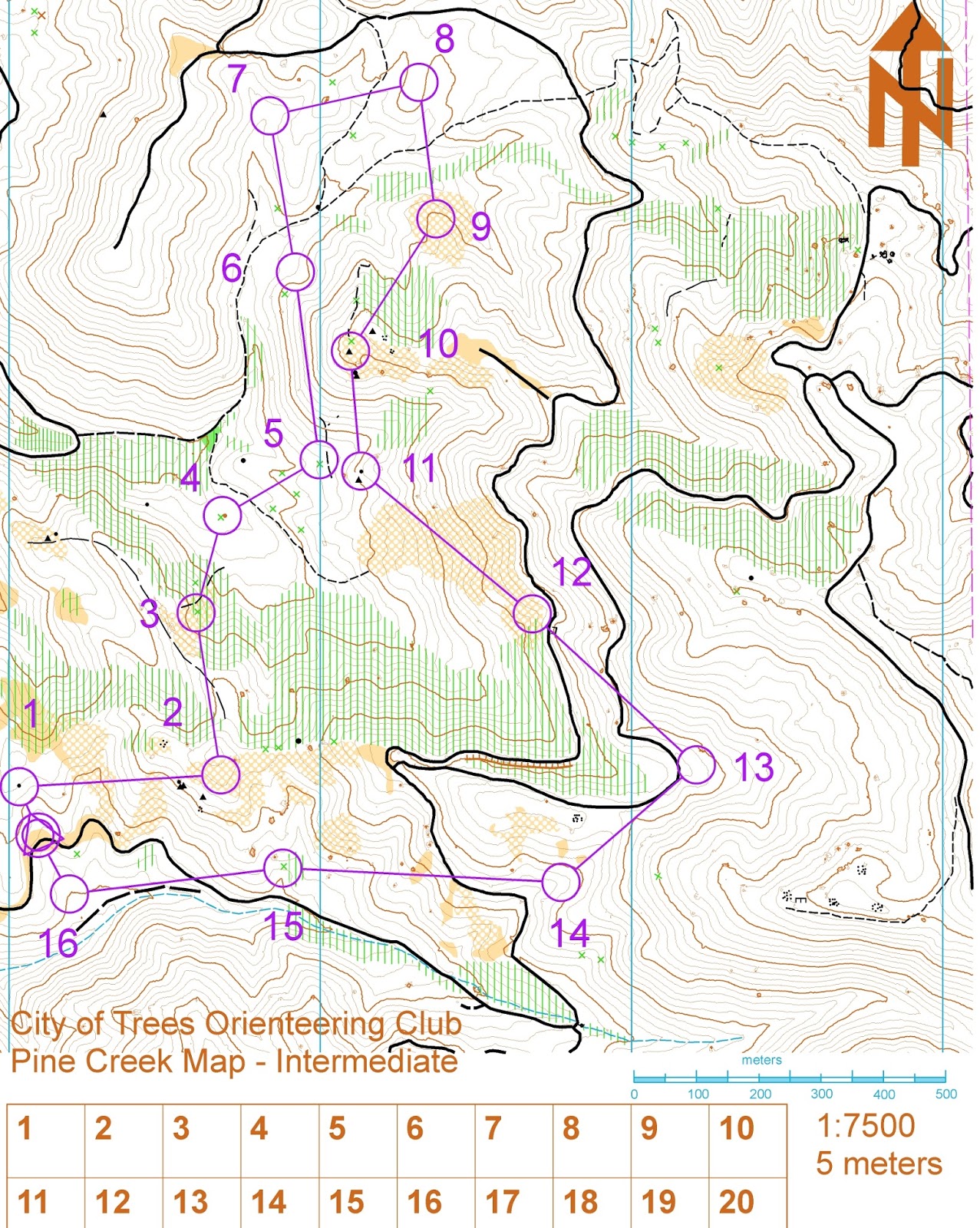
The Pine Creek Map covers some rough terrain making course design a challenge. Large elevation changes and long swathes of unrunnable vegetation awkwardly constrain design. Early on I concluded that I could only squeeze out a good navigator's course of about four kilometers. Some members of CTOC come for the workout as well as the navigation. For them I added four controls to the Intermediate Course to produce an advanced course with 600 meters of climb. Only Sergey took up the challenge. As he left the start we heard, “I'll be back in 60 minutes”. A quick consultation with the results below show how his usually reliable estimation failed him. Sergey, I really did not intend to hide Control #3. Or was it #2? Either one probably was a little more obscure than it should have been.

In the Orange category it took four adult women to edge out Katrina Wright. My sidekick, Norma Bailey, teamed up with Carrie Magnuson and her friends Lauren and Mikie. I saw something entirely new. Mikie carried a 35 pound pack to prepare of an outdoor class she'll be taking soon. From what I heard she didn't slow up the group. In my mind that's a terrific demonstration of strength. Lauren has been with us before. Join up, Lauren, we'd be pleased to have you as a member.
 

Bill Leahy signed up for the Advanced Course. After a little gentle persuasion he opted to compete with Jeff on the Intermediate Course. Jeff, one of our accomplished ultra-runners, completed a 40 mile competition the day before. He needed no encouragement to scale down to the Intermediate Course. On the “easy” course, Jeff was out for more than two hours to take first place. I suspect Bill is waiting for Jeff to run a 50-miler the day before a meet. Bill, let us know when we need to schedule that meet.

Melanie headed for the 1st control
It was good to see Greg and Melanie. Greg has been nursing injuries and unable to run this year. I know he's a tough guy. Tackling Pine Creek when out of shape is a tough challenge. In the spirit of
their adventure racing Greg and Melanie teamed up to finish togther.

There were others who were prepared to participate on July 10, but weren't able to adjust to the postponement. Karin Didisse was on site that morning. She reported a large herd of sheep at the start. In meteorological terms there was no precipitation, but apparently it was raining sheep. That could have been an interesting twist on a meet.

It's not clear where the August meet will be, nor is it clear when it will be scheduled or even if it will happen. Watch this space for further information.

John Murray
Meet Director


July 17, 2016

June 18 Bannock Creek Meet Report

Sorry for the delay! Finally I managed to find time to put our June report down and looks like I was able to publish results before John's J

On June 18 weather cooperated and it even became hot at the end of the meet for those brave souls who gathered on a remote spot in a place where there is no cell phone reception, real wilderness surrounds, there is plenty of climb, and spirits are always high.

Here are some results in no particular order.

Beginner 1.6km, 50m climb, 8 controls
Jennifer Smackey 37:46
Joan Kelley 1:01:10

Yellow/Orange 2.2km, 70m climb, 9 controls
Alden Koenig 46:18
Norma Beiley 1:23:16
Carrie Magnuson, Lauren Hennrich 49:02 + some Int.
Caroline Mclecly, Denise Lauerman, Cindy Jabonick 1:38 (missed 4&5)

Intermediate 4km, 250m climb, 9 controls
Ethan Treadvell 1:27:23
Zach Clayton 1:03:12
Natalie Pusch, Levi Schmitt 1:36:09
Mike Teller 1:33:05
Bill Leahy 2:09:35
Jerry Stewart 2:42

Advanced 6km, 380m climb, 14 controls
Ben Brock 1:42:22
Ole Bergset 2:52 (DNF)
John Murray 2:35:35

Let me know if I may misspell your name. Looks like we will have August meet as John and Carrie gracefully stepped forward to handle Bear Basin meet near McCall. More details to follow.

Yours,

Sergey Velichko

July 4, 2016

Pine Creek-- Sunday, July 17– A Mostly New LiDAR Map

Join us for our third orienteering adventure on the Bannock Creek LiDAR map. The  Pine Creek venue lies just south of June's Bannock Creek and connects to it. The terrain has similar runnable forest in mountainous terrain.   The Pine Creek terrain is also similar to Gold Rush above the hydro-mined area. Ponderosa Pines and Douglas Fir predominate in what is mostly a runnable forest on southern, western and eastern exposures. Northern exposures tend to support dense undergrowth. 

We are offering three courses. For the advanced orienteer there is a 6K course covering enough vertical to ensure a good workout in addition to the runnable forest noted above. The intermediate orienteer will travel mostly in runnable forest punctuated by numerous spurs and re-entrants. Novice orienteers will venture off-trail along linear features or will search for large prominent features.For those who have run Gold Rush many times this is an opportunity to use the same skills in new and unfamiliar terrain. Due to the absence of suitable trails there will be no truly beginner course. It will be necessary for participants on the novice course to identify features like boulders and re-entrants on the map. If you are a novice and unfamiliar with orienteering map symbols, the meet director and experienced orienteers will gladly give you a brief explanation before you depart on your adventure.
 
All three courses (novice, intermediate, and advanced) begin and end about five miles up the Pine Creek Road (USFS Road 304).

Because cut branches on the ground often make the footing unstable in many places, you should bring sturdy shoes and good judgment about when to be cautious.

In the desire to minimize waste and save myself some printing expenses, please RSVP to me no later than 5:00Pm Saturday, July 16 with your name and intended course choice (and if you want an extra map or two for a larger group.)  My email is jnm2870 AT cableone DOT net.  If you decide to show up impromptu, I expect to have a few blanks on hand and you will get to copy your course the old school way. Alternatively, call me at 208 342-2165.
 
Who: Orienteers of all ages, novice to advanced.

When: Sunday July 17. Courses will be open for starts from 10am – 12. Courses close at 2 pm. You may arrive within this window to try a course, as participants start separately a few minutes apart.

Finish and Parking Location: Pine Creek Road (USFS Road 304) at about mile 5  https://goo.gl/maps/PyS6igy5as82

Restrooms are not available. You should be responsible for your own water.
Format: Classic. 
Cost:  $10 per person/team, $5 for a single junior, free to CTOC members (more info here)
You may want to bring: a watch, a compass, a snack, a whistle and a cell phone. (Some compasses will be available to borrow)
A word about LiDAR: Several government agencies have acquired high resolution mapping data for land management. In Idaho many of the LiDAR projects are undertaken for hydrology studies. The process involves a low altitude GPS guided laser scan resulting in a digital elevation model with accuracy sometimes in a range below ten centimeters. These data have been made available free to the public in many cases.
Contours and trails on the Pine Creek map are accurate. The Pine Creek vegetation  has not been mapped in detail. Major areas of dense vegetation are noted in sufficient detail to allow the orienteer to make reasonable route choices.

Director: John Murray